
Modern Vehicle Land Navigation: Why GPS Apps and Analog Skills Both Belong in Your Rig
GPS tools like Gaia and onX are now mission-critical for off-road navigation, but paper maps and compass skills remain non-negotiable backups for serious overlanders.
Vehicle-based land navigation has changed more in the last decade than in the previous fifty years combined. The days of unfolding a USGS quad sheet across the hood, plotting a route in grease pencil, and hoping your odometer math holds up are largely behind us — at least as a primary method. Today, the overwhelming majority of serious off-road drivers, overlanders, and backcountry first responders rely on digital mapping platforms like Gaia GPS and onX Offroad to plan, execute, and document their routes.
And here's the part that ruffles some feathers in the traditionalist crowd: that's a good thing. Digital navigation is no longer a crutch. It's a legitimate, reliable, primary tool that — when used correctly — produces better outcomes than analog methods alone. But that doesn't mean you should leave the paper maps at home. Anyone who's spent serious time in the backcountry knows that "primary" and "only" are very different words.
Let's break down where vehicle-based land navigation stands in the modern era, why digital tools have earned their place at the top of the toolkit, and why analog skills absolutely cannot be retired.
The Digital Revolution in Off-Road Navigation
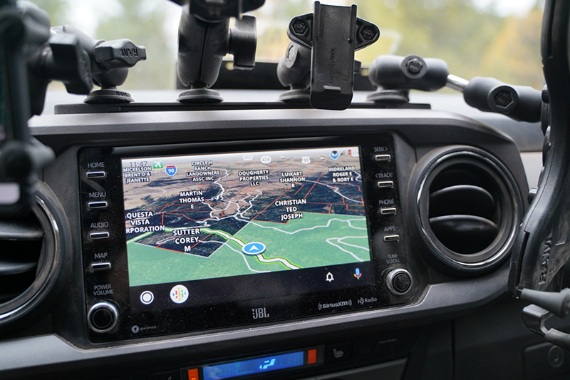
If you haven't used Gaia GPS, onX Offroad, or a comparable platform in the last few years, the capability gap between modern apps and the GPS units of even ten years ago is staggering. These aren't simple moving-map displays anymore — they're full-featured planning, execution, and documentation platforms.
What Modern GPS Apps Actually Do
The core feature set of platforms like Gaia and onX includes:
- Layered mapping — USGS topo, satellite imagery, MVUM (Motor Vehicle Use Maps), private/public land boundaries, slope angle shading, weather overlays, and historical fire data, all stackable and adjustable for transparency.
- Offline map downloads — Pre-cached map data that works with zero connectivity, often at full resolution across thousands of square miles.
- Track recording — Real-time logging of your exact route, speed, elevation profile, and time stamps.
- Route planning — Snap-to-trail routing, waypoint management, and turn-by-turn navigation on established trail networks.
- Cloud sync and sharing — Routes plotted on a desktop at home appear on the device in the truck, and tracks recorded in the field sync back automatically.
- Land status verification — Critical for confirming you're on legal trails, not crossing private property, and respecting wilderness boundaries.
Compared to a paper map and compass, this is a generational leap in capability. You can verify your exact position to within a few meters, check whether the road ahead is open or closed, see the slope angle of a climb before you commit, and overlay current weather radar — all simultaneously.
Connectivity Is No Longer the Achilles' Heel
The classic argument against digital navigation has always been: "What happens when you lose signal?" That argument held weight ten years ago. It holds significantly less weight today, for two reasons.
First, offline maps have matured. Both Gaia and onX let you download massive areas of high-resolution map data directly to your device. GPS itself doesn't require cell service — it's a satellite-based system that works anywhere with sky view. As long as your maps are pre-loaded, you can navigate confidently with zero cellular connection.
Second, persistent connectivity is now genuinely affordable. A few options worth knowing:
- Cell signal boosters — Units like the weBoost Drive Reach Overland can pull a usable signal from a tower miles farther than a bare phone, dramatically extending the area where you have live data, weather, and communications.
- Satellite internet — Starlink Mini and similar systems have changed the equation entirely. For a few hundred dollars in hardware and a monthly subscription, you can have functional internet from essentially anywhere with sky view.
- Satellite messengers — Garmin inReach, ZOLEO, and Apple's satellite features provide two-way text and SOS capability independent of cellular networks.
The point isn't that you should rely on internet connectivity to navigate — you absolutely shouldn't, and offline maps remain the foundation. The point is that the old "what if you lose signal" critique has been substantially mitigated by both better offline tooling and affordable always-on connectivity options.
Why Digital Primacy Isn't a Crutch
There's a strain of thinking in the outdoor community that treats reliance on technology as inherently weak — that "real" navigators use maps and compasses, and digital tools are for amateurs. This mindset is outdated and, frankly, counterproductive.
A modern off-road navigator using Gaia GPS effectively is exercising real, learned skill. Understanding map layers, interpreting MVUM data, planning a route that accounts for vehicle capability and seasonal closures, managing battery and power systems, maintaining offline data integrity — these are legitimate competencies. Dismissing them because they involve a screen is no different than dismissing a modern carpenter because they use a cordless drill instead of a hand brace.
The pilots flying you across the country use GPS as their primary navigation. The Coast Guard uses electronic charts. Modern military land navigation integrates digital tools at every level. The technology has earned its place because it works, it's reliable, and it produces better outcomes.
But Here's Where the Old Guard Is Right
Now we get to the part where the traditionalists deserve their due. Because while digital navigation has earned primary status, analog skills and tools remain absolutely required core competencies for anyone serious about backcountry travel.
Why? Because every digital system has failure modes, and the consequences of a navigation failure in the backcountry can be severe.
Failure Modes You Should Plan For
- Battery failure — Cold weather destroys lithium battery performance. A device that shows 60% at 70°F can shut off at 0°F. Vehicle electrical issues can take down your charging capability entirely.
- Device damage — Phones break. Tablets crack. A dropped device on a rocky shelf can end your digital navigation in an instant.
- Software failures — Apps crash. Updates introduce bugs. Map data corrupts. Operating systems decide today is the day they need to install a 2GB update.
- GPS signal degradation — Deep canyons, dense canopy, and certain atmospheric conditions can degrade GPS accuracy or eliminate the signal entirely.
- Vehicle separation — If you have to leave the rig — recovery on foot, injury evacuation, going for help — you may not be able to take the full digital setup with you.
- User error — Forgetting to download maps for the area, accidentally deleting tracks, fat-fingering a route on a small screen.
None of these failure modes are common. But none of them are rare enough to ignore, especially when the consequence of a navigation failure is being lost in country where help is hours or days away.
The Analog Skills You Still Need
Carrying a paper map you can't read isn't a backup plan — it's dead weight. The analog skills below aren't optional add-ons. They're the floor of competence for serious backcountry travel.
Map Reading
You should be able to look at a topographic map and immediately understand:
- Contour interval and what the spacing tells you about terrain steepness
- The difference between a ridge, a spur, a draw, and a saddle
- Map scale and how to estimate real-world distances
- Declination and how it affects compass work in your area of operation
- Map symbols for roads, trails, water features, and structures
- How to identify likely vehicle-passable routes versus foot-only terrain
Compass Work
A compass is useless if you don't know how to use it. Core skills include:
- Taking a bearing from a map and following it on the ground
- Taking a bearing on a terrain feature and plotting it on a map
- Triangulating your position from two or three known features
- Adjusting for magnetic declination correctly for your location
- Using terrain association to navigate without constant compass reference
Terrain Association
This is the skill that ties it all together — the ability to look at the country in front of you, look at your map, and reconcile the two. Good terrain association means you always know roughly where you are even without checking a device. It's pattern recognition, and it only develops through practice.
What Should Actually Live in Your Rig
Here's a practical loadout for vehicle-based navigation that integrates digital primacy with analog backup:
Primary (Digital)
- Tablet or phone running Gaia GPS, onX Offroad, or both, with offline maps pre-downloaded for your area of travel
- Hardwired 12V charging with a quality mount
- Backup power bank capable of fully recharging your device at least twice
- Optional: cell booster and/or satellite internet for extended trips
- Satellite messenger (inReach, ZOLEO, etc.) — this is a separate category but related
Backup (Analog)
- Paper topographic map(s) of your area of travel — USGS quads, National Geographic Trails Illustrated, or printed map books like Benchmark or DeLorme
- MVUM or relevant land management agency maps for trail legality reference
- A quality baseplate compass — Suunto MC-2, Silva Ranger, or equivalent
- A waterproof map case or pouch
- A pencil and small notebook for marking position, time, and route notes
Total cost of the analog kit? Under $100. Total weight? Negligible. There is no reasonable argument for not carrying it.
How to Actually Build the Skills
Owning the equipment isn't the same as having the skills. Here's how to develop and maintain real competence:
- Practice in the digital-off mode. On familiar trails, deliberately turn off your GPS and navigate with map and compass only. Verify your position periodically against the GPS to check yourself.
- Plan trips on paper first. Before you transfer a route to Gaia, lay it out on a paper map. Identify the major decision points, terrain features, and potential bailout routes by hand.
- Run regular position checks
TimberRaven Outdoors
Instructor & field professional at TimberRaven Critical Response LLC